

Saturday - Nov 9, 2024
Pass Mountain Trail Runs
Mesa, AZ
The Pass Mountain Trail Run is the second race in the Aravaipa Running – Desert Runner Trail Series, Arizona’s premier trail & ultra run series.
*Distances may vary slightly each year due to permitting.
Start Times
6:00 AM – 50 Mile Start6:55 AM – Sunrise
7:00 AM – 50K Start
7:45 AM – 25K Start
8:15 AM – 5K Start
8:30 AM – 10K Start
Bib Pickup
Friday, November 812:00-5:00 PMAravaipa Running Warehouse
2401 S 24th St. Phoenix, AZ
Phone (602) 786-8835
__________________________
-or- Saturday November 9
Packet Pickup 5:15 AM-9:00 AM
Usery Mountain Regional Park
Volunteer
We need help to make Pass Mountain Trail Runs possible. Volunteer perks include Aravaipa race credits and race swag!Race Perks
Gender specific cut race shirt
Charity Beer Garden benefiting Southwest Wildlife Conservation Center
Chip timed race results displayed at finish line
Scenic and challenging course on desert trails
Well stocked aid stations every 3.0 to 8.6 miles
Post race food (bagels, fresh fruit) & socializing
Live Tracking
Follow the 2024 Pass Mountain Trail Runs with live split points throughout the race.
Race Registration
| Until 6/30 | Until 10/6 | Until 11/4 | Race Week | |
| 5 KM | $40 | $45 | $50 | $55 |
| 10 KM | $55 | $65 | $75 | $85 |
| 25 KM | $90 | $105 | $120 | $130 |
| 50 KM | $130 | $145 | $160 | $170 |
| 50 Mile | $170 | $185 | $200 | $210 |
*Pricing does not include tax.
Save $7.97 (including tax) with our no-shirt option! Shirts are offered & guaranteed on race day if ordered by 10/20, otherwise shirts will be available on race day if there are extras.
Course Information

Date | Saturday, Nov 9, 2024
Start Time | 6:00 am
Time Limit | 16 Hours (10:00pm)
Distance | 50.1 Miles
Total Elevation Gain | 4,696 feet
Max Elevation | 2,596 feet
Women's Course Record | 10:26:40 - Courtne McIntosh (2022)
Men's Course Record | 7:41:01 - Nick Coury (2021)
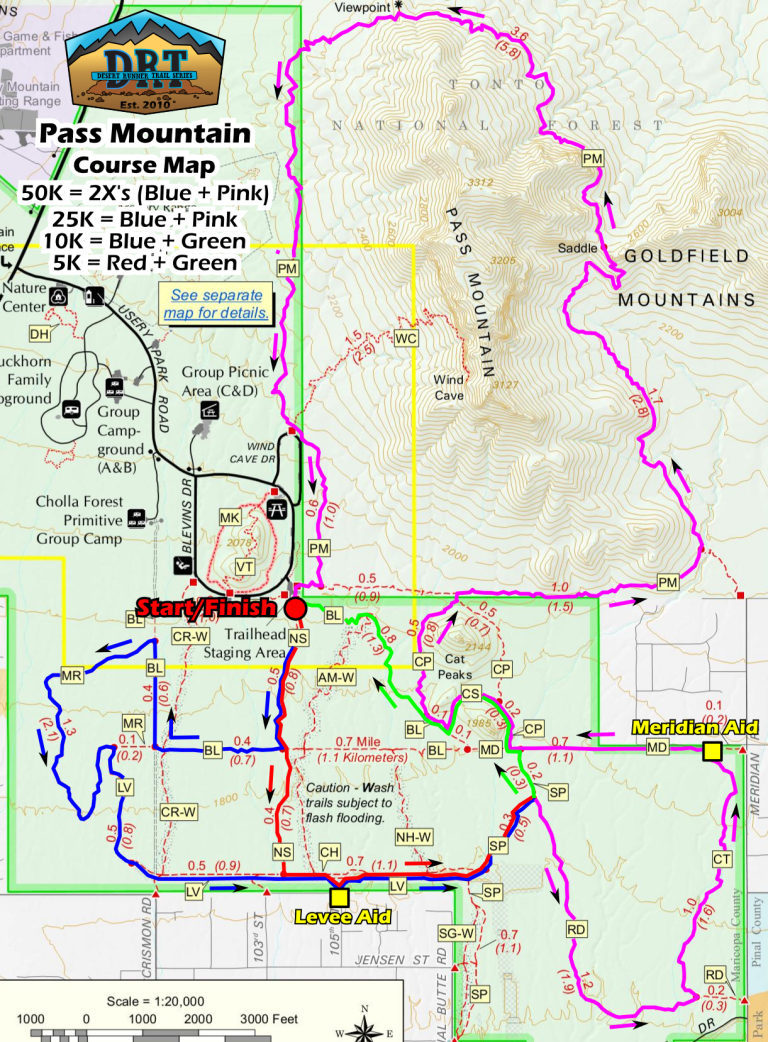
The 50 mile course will take runners outside of Usery Regional Park, heading through the northern edge of Apache Junction trails and through the lesser known but awesome Goldfield Mountains as you head north through the Tonto National Forest. The section of the Goldfields is mostly OHV trail with some single track mixed in while traversing the scenic Bulldog Canyon- crossing over and (running) through some sandy wash areas along the way. You’ll link to the Maricopa Trail around your halfway point, continuing northwest, and you’ll do loop in the fun and windy Hawes Trail System overlooking the Salt River and nearby buttes before heading back to Usery via the Pass Mountain Trail, this time from North to South, unlike the 25K & 50K races. It’ll be one final 50 mile challenge summiting Pass Mountain with 45+ miles on your legs but be sure to enjoy the view at the top.


Aid stations every 3.0 to 8.6 miles including water, electrolyte drink, sweet snacks, salty snacks, and fruit. Please plan to run with at least one bottle of water.
50 Milers: You will have longer stretches without aid (~10 miles), specifically once you leave the regional park. Terrain will be exposed, rocky, sandy, and hilly. Come prepared with plenty of water to be successful in the later stages of the race!
This is a CUPLESS Race. Please come prepared with your own reusable cup or you will be able to purchase a cup on site.
| 50 Mile | |||||
| Aid Station | Course Distance (Miles) | Distance to Next (Miles) | Crew Access | Drop Bags | Pacers |
| Start | 0 | 9.1 | Yes | Yes | No |
| Prospector Aid | 9.1 | 3.9 | No | No | No |
| Goldfield Aid | 13 | 8.5 | No | No | No |
| Bulldog Aid | 21.5 | 3.9 | No | No | No |
| Usery Aid 1 | 25.4 | 8.5 | Yes | Yes | No |
| Hawes Aid | 33.9 | 9.7 | Yes | No | Yes |
| Usery Aid 2 | 43.6 | 6.5 | Yes | Yes | Yes |
| Finish | 50.1 | Yes | Yes |
50 Mile Crew
You may have crews at Hawes Aid and Usery Aid (hit twice). Hawes Aid parking is across the Bush Highway from the aid station so use caution when crossing and only park in the parking lot (not off the highway).
50 Mile Pacers
Pacers are allowed beginning at Hawes Aid (mile 34) and Usery Aid II (mile 44). One pacer at a time, no muling. Pacers are not permitted for any of the shorter distances. Remote drop bags will be at Usery Aid which you will hit twice during your run.
Remote drop bags will be at Usery Aid which you will hit twice during your run. Drop Bags can also be left at the start/finish area.
7.5 hours for the 50 Mile to reach Usery Aid I – mile 25.5 (1:30 PM)
13 hours for the 50 Mile to reach Usery Aid II – mile 43.3 (7:00 PM)
16 hours for the 50 Mile (10:00 PM)

Date | Saturday, Nov 9, 2024
Start Time | 7:00 am
Time Limit | 15 Hours (10:00 pm)
Distance | 31.2 Miles
Total Elevation Gain | 2,680 feet
Max Elevation | 2,580 feet
Women's Course Record | 4:08:43 - Alisa Macdonald (2019)
Men's Course Record | 3:29:17 - Chris Mocko (2018)
Features winding trails throughout Usery Mountain Regional Park on the edge of the Goldfield Mountain Range. The start/finish will be at the Trail head Staging area.
The 50Km course consists of two 25Km loops, which includes some super fun trails through Cholla Forests, on the Levee Trail with perfect views of Pass Mountain and the Superstition Mountain range before climbing all the way up Pass Mountain in the Tonto National Forest. You’ll be treated to quite a view at the top before winding your way all the way back to the finish line.


Aid stations every 3.0 to 8.6 miles including water, electrolyte drink, sweet snacks, salty snacks, and fruit. Please plan to run with at least one bottle of water.
50 KM: You will have a longer stretch without aid between Levee Aid Station and the Start / Finish Line. Terrain will be exposed, rocky, and steep. Come prepared with plenty of water to be successful in the later stages of the race!
This is a CUPLESS Race. Please come prepared with your own reusable cup or you will be able to purchase a cup on site.
| 50K | Course Distance (Miles) | Distance to Next (Miles) | Crew Access | Drop Bags |
| Start | 0 | 3.8 | Yes | |
| Levee Aid | 3.8 | 3.1 | No | No |
| Meridian Aid | 6.9 | 8.8 | No | No |
| Start / Finish | 15.7 | 3.8 | Yes | Yes |
| Levee Aid | 19.5 | 3.1 | No | No |
| Meridian Aid | 22.6 | 8.8 | No | No |
| Finish | 31.4 | Yes | Yes |
Crews
Crews will be allowed at the start/finish.
Pacers
There are no pacers in the 50K. Pacers are ONLY allowed for 50 Mile runners.
We will have an area specified for your personal drop bag at the start/finish area that will allow for easy and quick access.

Date | Saturday, Nov 9, 2024
Start Time | 8:00 am
Time Limit | 14 Hours (10:00 pm Overall Cutoff)
Distance | 15.6 Miles
Total Elevation Gain | 1,336 feet
Max Elevation | 2,580 feet
Women's Course Record | 2:00:09 - Courtney Barnes (2019)
Men's Course Record | 1:42:40 - Charlie Ware (2022)
Features winding trails throughout Usery Mountain Regional Park on the edge of the Goldfield Mountain Range. The start/finish will be at the Trail head Staging area.
The 25 Km course includes some super fun trails through Cholla Forests, on the Levee Trail with perfect views of Pass Mountain and the Superstition Mountain range before climbing all the way up Pass Mountain in the Tonto National Forest. You’ll be treated to quite a view at the top before winding your way all the way back to the finish line.

Aid stations every 3.0 to 8.6 miles including water, electrolyte drink, sweet snacks, salty snacks, and fruit. Please plan to run with at least one bottle of water.
25 KM: You will have a longer stretch without aid between Levee Aid Station and the Start / Finish Line. Terrain will be exposed, rocky, and steep. Come prepared with plenty of water to be successful in the later stages of the race!
This is a CUPLESS Race. Please come prepared with your own reusable cup or you will be able to purchase a cup on site.
| 25K | Course Distance (Miles) | Distance to Next (Miles) | Crew Access | Drop Bags |
| Start | 0 | 3.8 | Yes | |
| Levee Aid | 3.8 | 3.1 | No | No |
| Meridian Aid | 6.9 | 8.8 | No | No |
| Finish | 15.7 | Yes | Yes |
Crews
Crews will be allowed at the start/finish.
Pacers
There are no pacers in the 25K. Pacers are ONLY allowed for 50 Mile runners.
We will have an area specified for your personal drop bag at the start/finish area that will allow for easy and quick access.

Date | Saturday, Nov 9, 2024
Start Time | 8:30 am
Time Limit | 13+ Hours (10:00 pm Overall Cutoff)
Distance | 6.2 Miles
Total Elevation Gain | 305 feet
Max Elevation | 1,894 feet
Women's Course Record | 40:13 - Abbie Tuomi (2020)
Men's Course Record | 38:41 - Devin Sharps (2023)
10km runners will stay on gorgeous trails within Usery Mountain Park winding through Cholla Forests with views of Pass Mountain & the Superstition Wilderness Area, finishing with a climb through Cat Peaks

10KM and 5KM runners will have access to one on-course aid station, Levee Aid, which will be stocked water, electrolyte drink, sweet snacks, salty snacks, and fruit. Please plan to run with at least one bottle of water.
This is a CUPLESS Race. Please come prepared with your own reusable cup or you will be able to purchase a cup on site.
| 10K | Course Distance (Miles) | Distance to Next (Miles) | Crew Access | Drop Bags |
| Start | 0 | 3.8 | Yes | |
| Levee Aid | 3.8 | 2.4 | No | No |
| Finish | 6.2 | Yes | Yes |
Crews
Crews will be allowed at the start/finish.
Pacers
There are no pacers in the 10K. Pacers are ONLY allowed for 50 Mile runners.
We will have an area specified for your personal drop bag at the start/finish area that will allow for easy and quick access.

Date | Saturday, Nov 9, 2024
Start Time | 8:15 am
Time Limit | 12+ Hours (10:00 pm Overall Cutoff)
Distance | 3.5 Miles
Total Elevation Gain | 221 feet
Max Elevation | 1,894 feet
Women's Course Record | 26:26 - Jennifer Vanos (2022)
Men's Course Record | 20:33 - Michael Schneider (2020)
5km runners will stay on gorgeous trails within Usery Mountain Park winding through Cholla Forests with views of Pass Mountain & the Superstition Wilderness Area, finishing with a climb through Cat Peaks

10KM and 5KM runners will have access to one on-course aid station, Levee Aid, which will be stocked water, electrolyte drink, sweet snacks, salty snacks, and fruit. Please plan to run with at least one bottle of water.
This is a CUPLESS Race. Please come prepared with your own reusable cup or you will be able to purchase a cup on site.
| 5K | Course Distance (Miles) | Distance to Next (Miles) | Crew Access | Drop Bags |
| Start | 0 | 1.2 | Yes | |
| Levee Aid | 1.2 | 2.3 | No | No |
| Finish | 3.5 | Yes | Yes |
Crews
Crews will be allowed at the start/finish.
Pacers
There are no pacers in the 5K. Pacers are ONLY allowed for 50 Mile runners.
We will have an area specified for your personal drop bag at the start/finish area that will allow for easy and quick access.

Pass Mountain Trail Runs Highlight Video
Additional Race Info
Park Entry Fee
Remember the park now charges a $7 park entry fee per vehicle. Please arrive early and have correct change (cash) available on race morning for a smooth entry process. Carpool to save! If you are participating in the double (day & night runs) your pass is good all day.
The start/finish line is located at the Trailhead Staging Area. Drive 1.4 miles past the park entry booth and turn left into the large dirt parking area. Overflow parking is available around the Blevins Drive Loop.
SHUTTLES: This event requires some of our entrants to park either off-site and be shuttled to the park (about 10 minutes) or within the park in the overflow lot, about one mile from the start/finish line and be shuttled over. This will specifically affect the shorter distances. Please plan accordingly.
Directions
From central Phoenix, I-10 east to US 60 east. Exit Ellsworth Road north to the Usery Mountain Regional Park entrance.

The race courses will be well marked with orange ribbons with black polka dots and reflective medallions. Trail junctions and turns will be marked with laminated signs. In addition, blue & white checkerboard plastic flagging will be hung to designate non-race or “WRONG WAY” trails. All runners are responsible for understanding the layout of the course. Please familiarize yourself with the course maps on our website prior to race day and/or print a map to bring along with you.
![]()
We will have our MedStar Solutions medical staff based at the start / finish headquarters to assist with first aid onsite. We reserve the right to pull you from the race if medical officials deem it necessary.
NOTE: Please do NOT call 911 in a medical emergency. Our medical team is highly trained and understands the terrain and driving access points. Please call the race day number and they will dispatch immediately.
Pets
For the safety of all runners, no pets are allowed on-course at the night runs. Any pets at the race must be on a leash at all times, respect park rules, and be supervised.
Camping
Usery Mountain Regional Park offers a campground with 73 individual sites. Each site has a large parking area to accommodate up to a 45′ RV and is a “Developed Site,” with water and electrical hook-ups, dump station, a picnic table, barbecue grill, and fire ring. Usery Mountain Regional Park provides immaculate restrooms with flush toilets and hot water showers. All sites in the campground are available on a first-come, first-served basis. Camping Fees
Trail Running and Trash
Please respect the trails and the beauty of the desert by disposing of any trash at one of our aid stations.
Trail Etiquette
Remember to always remain on designed trails, no short cutting.
If you decide to use headphones, please be respectful of runners behind you attempting to pass. Also, remove ear buds as you approach aid stations or a road crossing.
Please do not listen to music with a speaker (yes, we know you listen to the best music).
This course includes some legit single track. If you are fast and attempting to pass, please alert the runner in front of you before flying past them. Likewise, if you hear a runner approaching you from behind, attempt to find a spot to allow the runner to pass.
As a general rule, when passing a runner, announce, “on your left.”
Uphill runners/hikers have the right of way to downhill runners. Remain in control as you descend and respect the other
If you would like to join our volunteer team, we are looking for help with event setup, aid station, and event breakdown. Volunteer perks include a race goody and Aravaipa Race Credits. You can see our current opportunities and sign up below.
We also hold the Punisher Night Runs at this park the same day as Pass Mountain. Finish any distance at both races and receive a unique custom medal for completing our Double Down! Races for Punisher begin at 6 p.m. and include a 5K, 10K, 20K, and 30K.
Results & Photos
50 Mile | Male – 7:41:01 – Nick Coury (’21) | Female – 10:26:40 – Courtne McIntosh (’22)
50K | Male – 3:29:17 – Chris Mocko (’18) | Female – 04:08:43 – Ailsa Macdonald (’19)
25K | Male – 1:42:40 – Charlie Ware (’22) | Female – 02:00:09 – Courtney Barnes (’19)
10K | Male – 38:41 – Devin Sharps (’23) | Female – 40:13 – Abby Tuomi (’20)
5K | Male – 20:33 – Michael Schneider (’20) | Female – 26:26 – Jennifer Vanos (’22)
Past courses:
26K (2 13K loops in 2020) | Male – 1:44:51 – Dan Watson (’20) | Female – 2:07:02 – Anneke Thompson (’20)
26K | Male – 1:51:11 – Jules Miller (’13) | Female – 2:12:02 – Lauren Besenfelder (’12)
12K | Male – 45:40 – Boone Ebel (’13) | Female – 57:34 – Courtney Ellabarger (’12)
Results
2023| Results
2022| Results
2021 | Results
2020 | Results
2019 | Results
2018 | Results
2017 | Results
2016 | 50 KM | 25 KM | 10 KM | 5 KM
2015 | 50 KM | 25 KM | 10 KM | 5 KM
2014 | 50 KM | 25 KM | 10 KM | 5 KM
2013 | 50 KM | 26 KM | 12 KM
2012 | 50 KM | 26 KM | 12 KM
2011 | 50 KM | 26 KM | 11 KM
2010 | 50 KM | 26 KM | 10 Mile | 9 KM
2023 | Aravaipa Photo Gallery | Let’s Wander Photography
2022 | Aravaipa Photo Gallery | Callie Vinson | Nathaniel Chan Photos
2021 | Aravaipa Photo Gallery | Let’s Wander Photography
2020 | Aravaipa Photo Gallery
2019 | Aravaipa Photo Gallery
2018 | Aravaipa Photo Gallery
2017 | Aravaipa Photo Gallery | SweetM Images
2016 | Aravaipa Photo Gallery | SweetM Images
2015 | Aravaipa Photo Gallery
2014 | Aravaipa Photo Gallery
2013 | Aravaipa Photo Gallery
2012 | Aravaipa Photo Gallery
2011 | Aravaipa Photo Gallery
2010 | Aravaipa Photo Gallery

Thank you to our sponsors!

